The Road to Machu Picchu...through the Sacred Valley
The Inca trail is a picture at every turn. This is a picture looking down into the Urubamba Valley, the valley and river which Hiram Bingham followed to find Machu Picchu. In these hills are singular Inca storage houses, rocky burial caves, and grand Inca estates. This view of the Urubamba valley is spectacular. We had stopped at a roadside market--well, it was supposed to be a place to take pictures, but of course, there was a fairly good size market along the road. We bought ceramic water whistles and some inexpensive jewelry.
 Margaret had read about the Pisac Market and really wanted to see it. The Hursts and Dad and I visited the market in 2006 as part of our guided tour from Cusco to Machu Picchu and thought it was amazing--bags of corn, beans, many varieties of potatoes, herbs and seeds. The food stuffs were at the beginning of the market which seemed to stretch across 100 yards. There were stalls of sweaters, rugs, toys, and touristy memorabilia, fine jewelry, silversmiths, etc. This trip the Market was not part of the tour because it was not set up in Pisac. After the March floods, the villages held their own markets like the one we only looked at as we were walking toward the ruins of Ollantaytambo. I managed to shoot this picture as the van was pulling out of the congested parking lot.
  This is the official flower of Peru which looks suspiciously like the copiahue flower of Chile. Ofelia, our guide, said it is from the same flower family. The trumpet vine Grandpa had growing in the backyard of the house on 11th Avenue and at the St. George house must be from the same family.
  The Inca used terraces for farming and for grazing llamas. You can see the construction of the terraces clearly here. We also learned that pre Inca cultures used terracing as well. In the Lake Titicaca pictures, there is evidence of pre Inca terracing. Those pictures will be in a later blog.
 We stopped at an Inca burial site and storage houses built into the hillside. This was the beginning of the trail which led to the storage houses high in the hills. Emma and Margaret are standing on the narrow path not far from the boulder.
 This picture is looking down into the Urubamba River and valley. Some die-hard hikers hiked the Inca trail through the valley and along the river to reach Machu Picchu. I think I read it is a 4-6 day hike. We preferred the vans, train, and bus.
 These steps Ted is descending date back to the 1400s. The Inca built steps on the outside of their walls.
  This is a close up shot of the terraces used for gardening. They are more than 500 years old. Look to the upper right of the picture--the holes are burial caves. More than a 1000 mummies were found in excellent condition because of the burial practices of wrapping in a heavy woven material and placing the bodies in the fetal position for travel to the next life.
 This is a cemetary! You can see countless holes or burial sites over the entire hillside.
  While Dad and the Jeffries hiked to the storage houses you can see at the top and middle of the picture, I stayed on a lower path and took pictures. Each one of these terraces has a micro climate of its own. The Incas fertilized only the top terraces and allowed the rain to carry the nutrients to the bottom terraces.
 I took this picture of Ted photographing this massive boulder which blocked one half of the already narrow road. The van barely made it around the boulder. Ofelia said it has been there since the heavy rains in March because there is no way to move it or dispose of it. Go figure!
 Ollantaytambo is spectacular. This was a royal Inca stronghold, a fortress of magnificent size and area in the Sacred Valley. It connects strategically with the Inca Road to Machu Picchu, and it is about 2 hours from Cusco. The scenery is breathtaking and no camera could do it justice--high mountains still covered with snow, verdant hills, and a lovely valley of homes. Ollantaytambo is a living city which depends now on the tourist trade. The town offers guided bike tours and trails, fishing trips, hiking, and rock climbing.
  Ted, Margaret, and Kids are on one of the terraces in the center. They climbed the stairs to the top and came back by the same stairs. We lost track of them and thought they had taken a narrow trail across the mountain.
  The Jeffries are in just below on the staircase on the left. At the top are several homes and storage buildings. This site dates to the 1400s. To the right is a fountain which I thought I had a picture of. The fountain is four-sided. Water is collected from the streams and funneled through narrow aquaducts into four distinct natural fountains. I commented to Dad that I wished we could have such a water feature in our back yard. The Incas knew how to harness water, to channel sunlight, how to tell time by the sun shining through trapezoidal windows in their houses and temples, and how to use moonlight to plant and harvest.
 This view of the Urubamba valley is spectacular. We had stopped at a roadside market--well, it was supposed to be a place to take pictures, but of course, there was a fairly good size market along the road. We bought ceramic water whistles and some inexpensive jewelry.
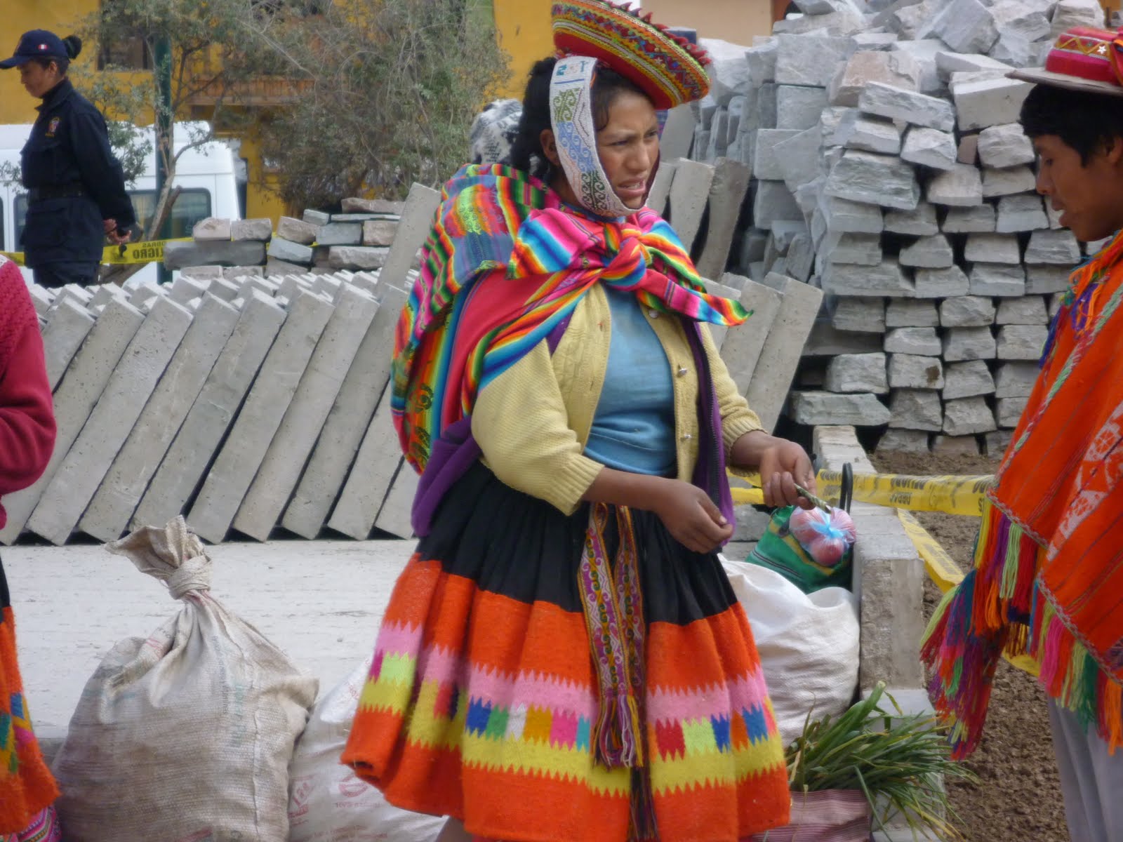 Margaret had read about the Pisac Market and really wanted to see it. The Hursts and Dad and I visited the market in 2006 as part of our guided tour from Cusco to Machu Picchu and thought it was amazing--bags of corn, beans, many varieties of potatoes, herbs and seeds. The food stuffs were at the beginning of the market which seemed to stretch across 100 yards. There were stalls of sweaters, rugs, toys, and touristy memorabilia, fine jewelry, silversmiths, etc. This trip the Market was not part of the tour because it was not set up in Pisac. After the March floods, the villages held their own markets like the one we only looked at as we were walking toward the ruins of Ollantaytambo. I managed to shoot this picture as the van was pulling out of the congested parking lot.
  This is the official flower of Peru which looks suspiciously like the copiahue flower of Chile. Ofelia, our guide, said it is from the same flower family. The trumpet vine Grandpa had growing in the backyard of the house on 11th Avenue and at the St. George house must be from the same family.
  The Inca used terraces for farming and for grazing llamas. You can see the construction of the terraces clearly here. We also learned that pre Inca cultures used terracing as well. In the Lake Titicaca pictures, there is evidence of pre Inca terracing. Those pictures will be in a later blog.
 We stopped at an Inca burial site and storage houses built into the hillside. This was the beginning of the trail which led to the storage houses high in the hills. Emma and Margaret are standing on the narrow path not far from the boulder.
 This picture is looking down into the Urubamba River and valley. Some die-hard hikers hiked the Inca trail through the valley and along the river to reach Machu Picchu. I think I read it is a 4-6 day hike. We preferred the vans, train, and bus.
 These steps Ted is descending date back to the 1400s. The Inca built steps on the outside of their walls.
  This is a close up shot of the terraces used for gardening. They are more than 500 years old. Look to the upper right of the picture--the holes are burial caves. More than a 1000 mummies were found in excellent condition because of the burial practices of wrapping in a heavy woven material and placing the bodies in the fetal position for travel to the next life.
 This is a cemetary! You can see countless holes or burial sites over the entire hillside.
  While Dad and the Jeffries hiked to the storage houses you can see at the top and middle of the picture, I stayed on a lower path and took pictures. Each one of these terraces has a micro climate of its own. The Incas fertilized only the top terraces and allowed the rain to carry the nutrients to the bottom terraces.
 I took this picture of Ted photographing this massive boulder which blocked one half of the already narrow road. The van barely made it around the boulder. Ofelia said it has been there since the heavy rains in March because there is no way to move it or dispose of it. Go figure!
 Ollantaytambo is spectacular. This was a royal Inca stronghold, a fortress of magnificent size and area in the Sacred Valley. It connects strategically with the Inca Road to Machu Picchu, and it is about 2 hours from Cusco. The scenery is breathtaking and no camera could do it justice--high mountains still covered with snow, verdant hills, and a lovely valley of homes. Ollantaytambo is a living city which depends now on the tourist trade. The town offers guided bike tours and trails, fishing trips, hiking, and rock climbing.
  Ted, Margaret, and Kids are on one of the terraces in the center. They climbed the stairs to the top and came back by the same stairs. We lost track of them and thought they had taken a narrow trail across the mountain.
  The Jeffries are in just below on the staircase on the left. At the top are several homes and storage buildings. This site dates to the 1400s. To the right is a fountain which I thought I had a picture of. The fountain is four-sided. Water is collected from the streams and funneled through narrow aquaducts into four distinct natural fountains. I commented to Dad that I wished we could have such a water feature in our back yard. The Incas knew how to harness water, to channel sunlight, how to tell time by the sun shining through trapezoidal windows in their houses and temples, and how to use moonlight to plant and harvest.
No comments:
Post a Comment